Today, Super Typhoon Ragasa has entered the East Sea, with an intensity that may reach level 17, with gusts exceeding level 17.
According to the National Center for Hydro-Meteorological Forecasting, Super Typhoon Ragasa in the East Sea has a strength equivalent to the maximum intensity of Typhoon No. 3 (Yagi) in 2024.
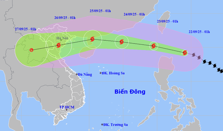
It is forecast that tonight (September 22), Super Typhoon Ragasa will move into the East Sea and become Typhoon No. 9. By early morning of September 25, the storm is expected to enter the Gulf of Tonkin, then make landfall from Quang Ninh to Ha Tinh.
→ Advisory on Coping with Typhoon No. 9 (Ragasa) for Automobiles
Before the storm
Minimize long-distance travel when the storm is approaching, especially on coastal routes, mountain passes, and areas prone to landslides.
Carefully check vehicle conditions: brakes, tires, windshield wipers, and lighting systems.
Fill up the fuel tank, prepare raincoats, drinking water, emergency food supplies, flashlights, and first aid kits.
Park vehicles in high, safe areas, away from trees, billboards, power poles, and flood-prone zones.
During the storm
Absolutely avoid driving unless absolutely necessary.
If caught in heavy rain and strong winds while driving: reduce speed, turn on low-beam headlights, and maintain a safe distance.
Do not attempt to cross deeply flooded areas or fast-flowing water → high risk of stalling or being swept away.
Avoid stopping or parking under large trees or near makeshift structures.
After the storm
Be cautious when traveling, as flooding, fallen trees, or landslides may still occur on roads.
Do not pass through areas with fallen power lines or collapsed utility poles.
Re-inspect the vehicle after the storm to ensure technical safety before resuming long-distance operation.